Welcome on my private webpage of the High Tatras presenting the beauty of these magic mountains in the northen of Slovakia. My pictures should express my respect and love for this wonderful peace of slovak nature. I am grateful to you for any remarks und suggestion (tatra_at_zboray_dot_com). One click on the pictures below will open you the door to the further interesting insights.


lomnickyobl1350_small.jpg (18569 Byte) 
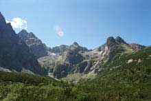
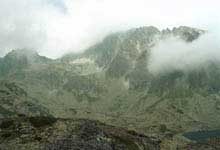
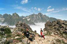
Above the city of Starý Smokovec dominates one great mountain - Slavkovský stít (2452,4m). The climb begins in Hrebienok (very often the scene of the Women Ski-World Cup). You need 3-4 hours to reach its top. The view from the top of this mountain ist abslotutely unique. On the right Lomnický stít, on the left Gerlach, in the front the whole valley Velká Studená dolina.


zbojchata_small.jpg (18037 Byte) Because of its great variety and central position  belongs the valley Velká Studená dolina to the most visited valleys in the High Tatras. Unfortunatelly, the hut Zbojnícka chata burned to a cinder on 18. 6. 1998 - today again working. The passes Prielom und Priecne sedlo attract all experienced hiker. Prostredný hrot is one challenge for every mountainer.


rysykrivan_small.jpg (16192 Byte) Kriván (2494,7m) dominates on the western side of High Tatras. Because of its typical shape you cannot mistake it for someone else. The climb takes approximately 4-5 hours. Kriván is for all Slovaks the holy mountain. The panorama view from its top is fascinating. You can see all valleys, hills and ridges of the High Tatras like from the airplane. 


rysyfero_small.jpg (16337 Byte) Rysy (2499,6m) with the highest situated hut in the High Tatras Chata pod Rysmi (2250m) are unforgettable. The climb from the hut Chata kapitána Morávku (1500m), through tha valley Mengusovká dolina, passing the lakes Zabie plesá (1919m), conquers every visitor's heart. Legendary and cool northwall of Ganek (2459m) is a challenge for all generations of mountainers. 


mlynicka_small.jpg (18466 Byte) Mlynická and Furkotská dolina create one very popular hiking ring. Duration approximately 8 hours. Startingpoint is the village Strbské Pleso (in the year 1970 held of the world championship in nordic skiing). Very impressive is the climbing on the Bystré sedlo. Wonderful is also the waterfall Skok. Because of the law temperature refresh the many lakes only the strong man.


bielavodahreben_small.jpg (13613 Byte) Many climbers know the valley Dolina Kezmarskej Bielej vody. You need approximately 3 hours from busstop Biela voda (from Tatranská Lomnica direction Polen) to come to the hut by the lake Zelené pleso. The famous northwall of Kezmarský stít, Baranie rohy, Jastrabia veza, Jahnací stít fulfill all wishes. There are several camps for mountainers in that valley.


velickesliezky_small.jpg (12518 Byte) The valley Velická dolina with the mountain hotel Sliezky dom (1670m) and with one of the most beautiful lake in High Tatras Velické pleso attract a lot of mountaineers. The pass Polsky hreben (2319m) offers the possibility to come through Bielovodská dolina. It lasts from Tatranská Polianka to Lysá Polana 8-10 hours, but it is worth it.


gerlachbatiz_small.jpg (11917 Byte) Batizovské pleso (1884m), Batizovská dolina, Batizovský stít (2448m) together with the highest Peak of Slovakia Gerlach (2654,4m) make a powerfull impression. The climb from Vysné Hágy lasts 2 - 3 hours. You need also good weather to enjoy the beauty of this respectful piece of the High Tatras.  


studvpotok5_small.jpg (19494 Byte) Changes of one brook. That is probably the suitable name for this links. The brook Velký studený potok below the valleys Velká and Malá studená dolina, with numerous waterfalls and whirlpools, with crystal-clear water and deep forest around, is a pearl of this region.


moravkova_small.jpg (15644 Byte) The mountain lake Popradské pleso (1500m) belongs to the largest in the High Tatra. The walk from Strbské pleso through a very beautiful forest is very easy and ranks among the promenades in these mountains. Popradské pleso with the mountain hotel on the bank is actually only one stopover on the way to the peaks, like Rysy (2499,6m) or Vysoká (2547,2m)


On the individual pages with pictures you can find the exact geaograpic names. I couldn't translate these names to English, because you find even those Slovak names on any hiking map. By the way the names of the peaks of Higt Hatra are almost token from the small towns situated bellow the hills.

______________________________________________________________________

Osttirol Photogallery   High Tatras Photogallery    Famous Graves    Landscape    Venice